[cmsms_row data_width=”boxed” data_padding_left=”3″ data_padding_right=”3″ data_color=”default” data_bg_color=”#ffffff” data_bg_position=”top center” data_bg_repeat=”no-repeat” data_bg_attachment=”scroll” data_bg_size=”cover” data_bg_parallax_ratio=”0.5″ data_color_overlay=”#000000″ data_overlay_opacity=”50″ data_padding_top=”0″ data_padding_bottom=”50″][cmsms_column data_width=”1/1″][cmsms_text animation_delay=”0″]
The Renosterveld of South Africa’s Overberg is one of the world’s most species diverse mediterranean type shrublands, but it is also one of the most threatened ecosystems worldwide. Only around 5% of the original extent of this vegetation remains. One of the main threats is illegal ploughing due to expanding agricultural lands into the surrounding Renosterveld.
Research by Glenn Moncrieff and colleagues at the Fynbos Node of the South African Environmental Observation Network (SAEON) found that a total of 478.6 hectares of Renosterveld vegetation was lost to illegal ploughing from 2016 to 2020, representing a total of 0.72% of the remaining natural vegetation in the region.
With such a significant loss of Renosterveld over such a short time, an effective monitoring solution that can detect potential land cover change events such as illegal ploughing is needed.
Using a combination of satellite imagery and machine learning, Glenn Moncrieff and Marcel Gietzmann-Sanders have developed the Global Overberg Renosterveld Watch application, which starts to address this urgent need for an effective remote sensing solution that can be used to detect changes so that resources can be assigned as needed to start to tackle the problem on the ground.
The technology is developed based on the Global Forest Watch application, which uses Google Earth Engine and satellite imagery to document deforestation in Brazil. The satellite imagery which is used is now globally available, documenting land cover change around the world over several decades.
With further work and the application of machine learning to build algorhythms that teach the software to identify the differences between Renosterveld vegetation and transformed agricultural land, this technique can now be used to quickly identify illegal ploughing events within days of their occurrence.
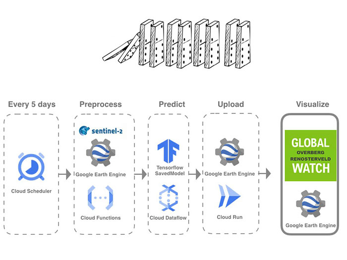
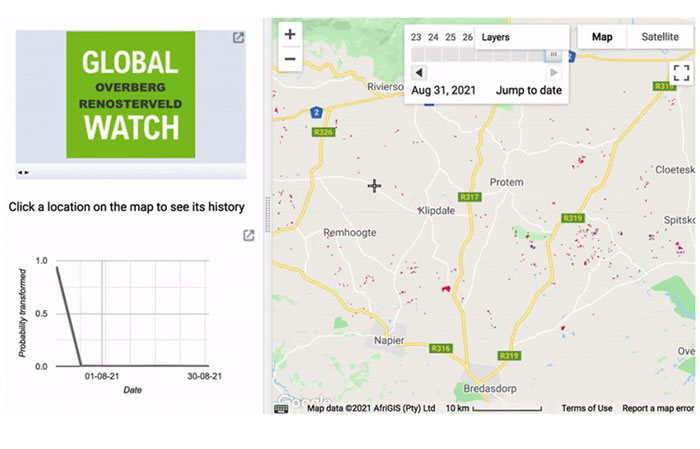
Whenever new satellite imagery becomes available, these models can then be run to automatically highlight areas where land cover change may have taken place. At present, these models are being run every five days.
These changes in Renosterveld vegetation can even be detected prior to complete transformation has taken place. Often in areas where illegal ploughing is about to take place, the veld is brush cut. This means that even these changes can be detected prior to the area being ploughed, which means that areas where interventions are needed can be identified and targeted prior to complete loss of the Renosterveld vegetation.
The Global Overberg Renosterveld Watch application is now available online via cloud services and can be viewed wherever there is an internet connection anywhere in the world. The application runs effectively and is extremely cost effective.
As these technologies become available and are further developed, it means that ‘eyes in the sky’ from satellite imagery can translate into people on the ground who are then able to target where monitoring of potential illegal ploughing events takes place.

Above: One of the threatened Polhillia species in the foreground, with most of the population (and an entire habitat) ploughed up unlawfully.
This increases the likelihood of awareness among biodiversity professionals and enforcement of the occurrence of illegal ploughing events (a function of the Department of Environmental Affairs and Development Planning, as well as the National Department of Agriculture, Land Reform and Rural Development).
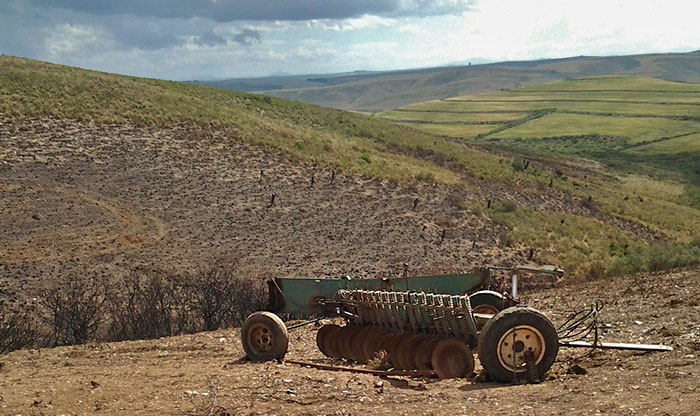
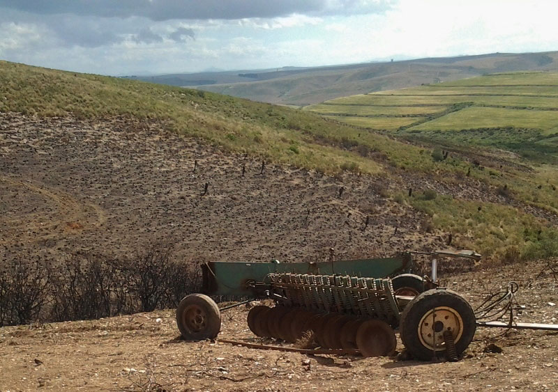
Above: Burning of veld is often followed by unlawful ploughing of the last remnants of Critically Endangered renosterveld.
No longer can Renosterveld quietly disappear piece by piece without anyone noticing patches of Renosterveld shrinking year on year or vanishing altogether.
This technology also has significant potential application in providing evidence for enforcement, so that it can be proven using data and imagery that land cover change has definitely taken place, as well as when it took place. It is hoped that the Global Overberg Renosterveld Watch will play a significant role in slowing down the illegal loss of these highly biodiverse, threatened ecosystems.
Further Reading
Moncrieff, G.R. (2021) ‘Locating and dating land cover change events in the Renosterveld, a Critically Endangered shrubland ecosystem’, Remote Sensing (Volume 13): pp. 1-13.
[/cmsms_text][/cmsms_column][/cmsms_row]